Took the trek in to check on the progress of this site recently. Part of our strategy against Wallaby predation, as well as using big guards, had been to plant Mountain Ash among some of the large dead Sycamore Maple that had been fallen at the site. Initially it had seemed that this plan had worked a treat, but we had underestimated the Wallabies and last time I visited the site (6 months ago) the pesky Macropods had pretty much munched all of the carefully placed plants; all but confirming that our conventional method of using big wire mesh tree guards is the only way to beat these beasts.
Even species that were meant to be Wallabies least preferred food such as Olearia lirata (Snowy Daisy-bush) were being heavily chewed.
On this visit things were actually looking a little better and it seemed that there had been some recovery of planted tubestock; although the ones not properly guarded were not much bigger than when they were planted over 18 months ago.
The Sycamore Maple which had once completely covered the 2ha site is also not giving up without a fight. A clamber around the site revealed many seedlings emerging and we as a group will focus on removing them before they become large feral trees. On the plus side there is mass natural regeneration of native understorey occurring with an impressive diversity of species, including plenty of Wattles; that have germinated without the aid of fire. The Maple logs that we left in-situ have been a massive bonus because the micro-climate they created has been perfect for fern regeneration, which is happening all over the site. The logs are breaking down quickly now with a variety of Fungi helping the process. We will have another planting day later in the year on this site (using the big Wallaby guards) so keep a look out for it if you are keen to lend a hand.
Overall view of site, showing the mass regeneration of shrubby understorey.
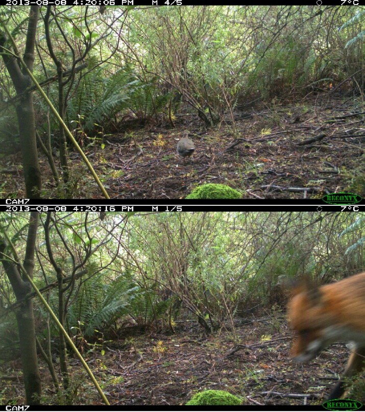
Hiding among the undergrowth a planted Mountain Asf
Snowy Daisy-bush showing the impact of Wallaby grazing.
New Sycamore Maple Seedling emerging.
Rainbow Fungus – Trametes versicolor aiding the decay of the Maple logs.
Logs left on the site aiding fern regeneration
Another log microhabitat providing a great site for fern regeneration.
Prickly Coprosma full of red berries
Lots of Kangaroo Apple with ripe fruit at the site.
Naturally Regenerated Tree Lomatia
Pine Tree that should have been dead by now.
No shortage of Sycamore Maple on site to be found and exterminated.
Yesterday we had our biannual photo-monitoring session, so this one is very up to date. We got on to this site a bit late (over a year after the fire) but we were intrigued with the mass regeneration of Eucalyptus seedlings (probably Mountain Ash) on the site and figured it would be good to record what happens to them over time. You can see in the early photos the shape of the slope, the dead trees and the mass of green that is the newly germinated plants. Now the shrubs in the foreground have grown and blocked our view, which seems to be a common issue with photo-monitoring but we will still keep tabs on the site and its future development.
Another series of photos, showing the recovery of burnt vegetation over time, this site is on an exposed north facing ridge, where the fire was fairly intense. Some sections of the burnt areas along the Grand Ridge Rd had trees that were mature enough to release lots of seeds and in those spots there has been thick Eucalyptus regeneration. Another large area further west was formerly fully cleared land, which had been replanted with Mountain Ash in the early 1990’s unfortunately these trees had not reached adulthood, which meant that the Mountain Ash, (which cannot re-sprout after a fire like other Eucalyptus species) were all killed; no seed to release meant that no new trees germinated after the fires only understorey. Friends of Tarra-Bulga National Park have just received a Communities For Nature grant to re-establish canopy trees at this site.
Friends of Tarra-Bulga National Park began a Photo-monitoring project back in 2007 as a way of using images to keep a record of the changes in vegetation in the park, especially in spots that were regenerating or likely to be impacted by disturbance (Such as timber harvesting in land adjacent to the park). The most interesting photo-points in the short term at least have been sites impacted in the 2009 fires. Here is a time-lapse video showing the progress of recovery from a site along Bulga Park Rd, just South of Balook. The vegetation type is Wet Forest.
The recent news involving a Sea Eagle flying off with a remote camera in the Kimberley has inspired us to put together this video of a Superb Lyrebird, that seemed to think the reflection in the front of the camera was a rival and hence went to war. This happened in September 2012 and thankfully we have not had a repeat. However we did stop putting cameras quite so close to the ground.
Technology today has made it super-easy to dig up fascinating old newspaper articles like this one below from the Argus in 1925. We would have to think that the author would be fairly astounded if they could step forward in time and visit the Tarra-Bulga today. What will it be like 88 years from now??
THE TARRA VALLEY.
When in 1840 Strzelecki led an expedition from New South Wales over Mount Kosciusko and through Gippsland to Corinella, on Westernport Bay one of the party was an Australian aborigine named Charley Tarra. The choice of this native was fortunate for in the latter part of the journey when food supplies were exhausted it was Charley Tarra’s prowess as a hunter that saved the party from starvation.
To such straits were they reduced to in the last 50 miles – and so wild and rough was the country that it took them 22 days to hew their way through the bush – that they lived almost wholly on the flesh of Koalas or native bears. A few months later when a party from Melbourne chartered a vessel to carry them to the newly discovered province, they took with them Charley Tarra, and when they, or rather some of them were cutting their through the tangled way undergrowth back towards Westernport Tarra’s gun frequently provided the hungry travelers with bear flesh. Which if not tasty, at any rate had food value, It was therefore fitting that Tarra’s name should be preserved in the nomenclature of the streams of Gippsland and, on a river rising in the hills 10 0r 12 miles from where the town of Yarram has since been built, and flowing through a wilderness of bush and fern trees, was bestowed the name of Tarra. It is not an imposing stream, and along most of its course the beautiful surroundings have vanished.
Making a Hill Road (Source: Monash University Centre for Gippsland Studies)
As one wanders in South Gippsland with its hundreds of bare hills or if not bare then covered only with dead eucalypts, or through the lower lands that have nearly all been devastated by fire, it is difficult to picture what this great territory was like when it was first explored, or even to visualise it as it was half a century ago. But a page or two of “the universal and public manuscript” that at one time was expanded to the eye of all can still be seen in the upper part of the valley through which the Tarra River flows. They are not unsullied pages, for every here and there one comes on patches of dead trees looking like phantoms of the surrounding living giants, with their marble like boles. On the hills and in the valleys, the fern trees rise above a tangled wilderness of blanket-wood, hazel, and other scrubs peculiar to the virgin mountain forests of Victoria. Far down in the main valley and in the trackless ways of the Tarra’s gully tributaries are bowers of myrtles of various sizes and conditions, some lithe and fresh others old and hung with lichens. Along the road over the hill big hearted settlers, in spite of great difficulties and discouragement, have built homes and cultivated little clearings.
Hill farm in the Tarra Valley – (Source: Monash Uni Gipps Studies)
In some cases, however, the odds have proved too tremendous, and scrub and bracken are almost hiding from view the abandoned homesteads. Near the top of the range where the Tarra River has its source is a timber mill, and though all the machinery is still there it seems a long while since the mill was in operation Scores of white logs mark an old timber trail now partly over grown with young scrub, and the bush is gradually creeping back around the mill and the timber-getters’ huts.
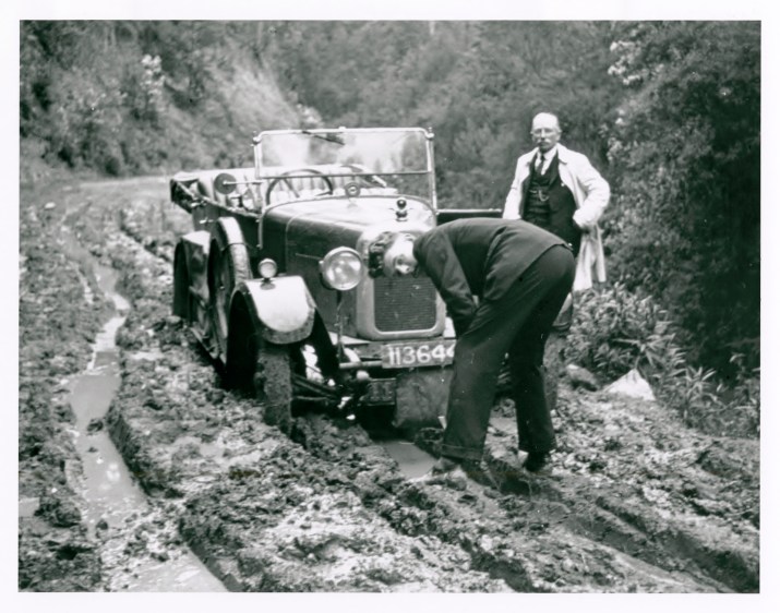
Car at Tarra Valley – Source: Monash Gipps Studies.
Near its source the scenery of the Tarra River is not surpassed by the beauty of any other valley in the State, but it is not likely to attract tourists. For the greater part of the year the road through it is almost impossible for motors, and there is too much stale, flat, and unprofitable country to be gone through to make the trip suitable for a walking tour. The bit of wild bush that is left is but a scrap of a mighty forest that 50 years ago covered South Gippsland, and this probably must ere long be destroyed and the name of the Tarra Valley be recorded only in the catalogue of things that were and cannot be again.
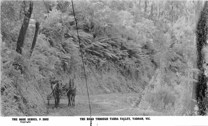
The Road Through Tarra Valley (Source: State Library of Victoria)